
Pregnant doe resting in woods at Eagleridge Bluffs. Photo: Ned Jacobs |
|||||

Harriet Nahanee arrested, Eagleridge Bluffs, 25 May 2006. |
First Nations elder Harriet Nahanee (Tsibeotl) was arrested on 25 May 2006 for blockading the construction of the Sea to Sky Highway at Eagleridge Bluffs (left). Lil'wat Rosalin Sam, condemned Harriet's arrest: "This move by the developers and the police unmasks the true driving force behind the 2010 Olympics. This is not about a peaceful meeting of the nations: this is about railroading destructive mega developments into our territories" 25 May 2006: Press Release. |
||||
Above: To assert her indigenous rights as an Indian under the Canadian Constitution, Harriet Nahanee holds in one hand the Mohawk warrior flag - a symbol of Indian resistance - and in the other the 1763 Royal Proclamation. Petition: "We, the undersigned, condemn BC Supreme Court Justice Brenda Brown's handling of contempt of court charges against 71 year old native Elder Harriet Nahanee, which resulted in a 14 day jail sentence on January 24, 2007. Respected Elder Nahanee filed an appeal, but died shortly after being released from Surrey Pre Trial Services Centre. The public now demands that BC Attorney General Wally Oppal and BC Premier Gordon Campbell launch an immediate public inquiry into the Supreme Court of BC's treatment of Respected Elder Harriet Nahanee. |

Banner: "No Olympics on Stolen Native Lands." |
||||
Ever since the late 18th century, the land and waters of what is now British Columbia have provided the resources for a boom & bust exploitation industry that enormously profited Europeans. From the fur trade and the gold rush, to the settlement eras, the pattern continued with forestry, fishing and mining industries. Where the natural resources have been used up, land speculators and property developers have taken over, converting unceded indigenous land into subdivisions and recreational resorts. Most of West Vancouver was developed by British Properties which is today posed to continue its habitat destroying activities at Eagleridge Bluffs (right). To facilitate a massive development push by big business into Squamish Territory, politicians committed $775 million of public funds for the expansion of the Sea to Sky Highway, part of its $3 billion infrastructure plan to further congest Greater Vancouver. |
Eagleridge Bluffs. |
||||

Royal Proclamation of 1763. The stand of Harriet Nahanee at Eagleridge Bluffs is supported by Squamish elder Gerry Johnson who holds the hereditary title Chief Capilano. In a televised interview at the protest site (right) on 16 May 2006, he warned the citizens of BC to wake up to the illegal actions of their elected officials who are encouraging development projects without having first legally established Aboriginal Title: "This is Squamish land, unceded, unsold Squamish land." See the CBC video clip: Aboriginal Elders Join Eagleridge Protest. Chief Capilano and Harriet Nahanee say they have a hereditary and sacred duty to protect the land, water and air and to pass it on to future generations in a clean state. |
Harriet Nahanee (nee Jones) is a Pacheedaht. She was born on the Pacheena Indian Reserve No. 1 in Port Renfrew on Vancouver Island in 1935. Harriet's mother, Ada Kay, belonged to the neighbouring Didiaht First Nation. Harriet does not recognize either the government of Canada or BC. She says: "No Treaty - No Jurisdiction" and she demands justice according to the 1763 British Royal Proclamation (left) which states that Nation to Nation treaties must be negotiated and signed before aboriginal land is settled by non natives. Chief Capilano, 16 May 2006. |
||||

Sea To Sky Highway, November 2006. |

Sea To Sky Highway, November 2006. |
||||
|
Eagleridge Bluffs is a rare urban rock outcrop and unique wetlands habitat. See: Native Plant Society of BC (2001). Kiewit and Sons, the American corporate partner of BC's Ministry of Transportation, is destroying this habitat for highway expansion (above l.). Dynamite charges are placed in deep drill holes with red collars prior to blasting (above r.). Following her arrest, Harriet again defied the injunction and returned to Eagleridge Bluffs with the non native forest activist Betty Krawczyk on 4 June 2006 to say prayers for the dead and dying creatures and to give a traditional death song for the land in her Pacheenaht language (right). Harriet is the granddaughter of Queesto, the legendary Pacheenaht hunter of whales and hereditary chief from Vancouver Island. Her uncle described their remarkable family heritage: Queesto, Pacheenaht Chief by Birthright (1981). |

Death song by Harriet Nahanee (right). |
||||

Arbutus grove at Eagleridge Bluffs, May 2006. Harriet is concerned that the young people are losing their traditional culture. She says that when her society was organized under the hereditary chief system, the values of family, religion and ritual were foremost and these were passed on to the children: "They were taught to respect the earth. To respect each other. To respect the animals. They were taught respect, and with respect there is no need for laws." Harriet herself is a survivor of the residential school system about which she says: "I was abducted at the age of five by terrorists: the government agents (Department of Indian Affairs); the church missionaries; and the RCMP officers." Harriet has kept her traditional knowledge despite the odds and she is proud of not having been assimilated by settler society. See: Still On the Healing Path. The jailing of Harriet on 14 January 2007 for standing up for her indigenous rights by protecting Squamish tribal land from development is evidence of the apartheid policy described in the milestone 1966 speech "The BC Indian Land Question and the Rights of the Indian People" by Thomas R. Berger. |
Harriet moved to the Mission Indian Reserve in 1955 when she married Squamish member Harold Nahanee with whom she had seven children. She hunted deer above Eagleridge Bluffs with her husband, in an area where today many unique specimens of the rare and beautiful red barked arbutus tree survive (left and below). Harriet objects to the destruction of this ecologically rich habitat for highway expansion on the grounds that the Squamish hold Aboriginal Title to the land and that it must be saved for future generations. Arbutus at Eagleridge Bluffs, May 2006. |
||||

"No Olympics on Stolen Land," Sutikalh, 2006. |
Native Youth Movement activist Billie Pierre says: "BC is using the Olympics as a cover for a gigantic land grab. It is worse than the BC Treaties because our legal ties to our territories are not addressed. Even our corrupt 'leaders' are being bought off at a smaller price. Mega - tourism projects are being developed on so - called 'Crown Lands' or 'Public Lands.' Corporations are being given leases to build trams and other structures for the resort projects. The lands at the bottom of the mountains become privately owned. That's where the real money is made: through real estate" (7 September 2004, Seven Oaks). Sutikalh activists in St'át'imc Territory issued a warning about real estate speculation on unceded First Nations land: No Olympics on Stolen Land. |
||||
Most of the Sea to Sky Highway expansion occurs on Squamish Territory. It is designed to serve the huge surge in population growth and economic development resulting from the 2010 Winter Olympics, from Vancouver to Whistler. Located on the highway overlooking Howe Sound at the base of Britannia Mountain is the Britannia Mine (right), notorious as the most contaminated site in North America. Once the biggest copper mine in the British empire, when it closed in 1974 it left behind a dark legacy of toxic pollution that continues today to seriously degrade Howe Sound. Woodfibre pulp and paper mill. |

Britannia Mine, 26 April 2006. The Britannia Mine property was sold in 1978 by the Anaconda Mining Company to the Copper Beach Estates development company. In 2003 McDonald Corporation bought it and sold a waterfront section to the Tanac Development Corporation. It developed the property as the exclusive Furry Creek Golf Course and residential complex which is still expanding. Furry Creek is an ancient and sacred bathing place for the Squamish people and its loss as an aboriginal heritage site is a sorrow to many in the community. Four miles south of Furry Creek another waterfront property is being developed at Porteau Cove by Pacific Place Development (Concord Pacific Inc.). |
||||
Industrial sites have degraded Howe Sound with pollution caused by countless toxic spills. See: Ecotoxicology. Now that the natural resources have been depleted, these sites are being remediated as lucrative real estate schemes like Furry Creek. The pulp mill at the town of Woodfibre was abandoned by the forest industry in 2006 after 92 years of profitable operations (above). Western Forest Products, owner of the Woodfibre mill, is currently selling large sections of its forest land on Vancouver Island to property developers. Such real estate deals are a greater threat to Squamish sovereignty than resource extraction and more profoundly degrading to the ecology of Squamish Territory. The Skwxwú7mesh speaking people known today as the Squamish Nation are the indigenous inhabitants of the land and waters spanning the Sea to Sky Highway which cuts through the middle of unceded Squamish Territory from Vancouver to Whistler. In response to the continued encroachment of Squamish Territory, the Squamish Nation released Xay Temíxw - Sacred Land - in 2002. A map shows five Kwa Kwayk welh-aynexwd - Wild Spirit Places - where Squamish forest heritage is to be fully protected. "Cedar Woman," Upper Elaho, 2006. |
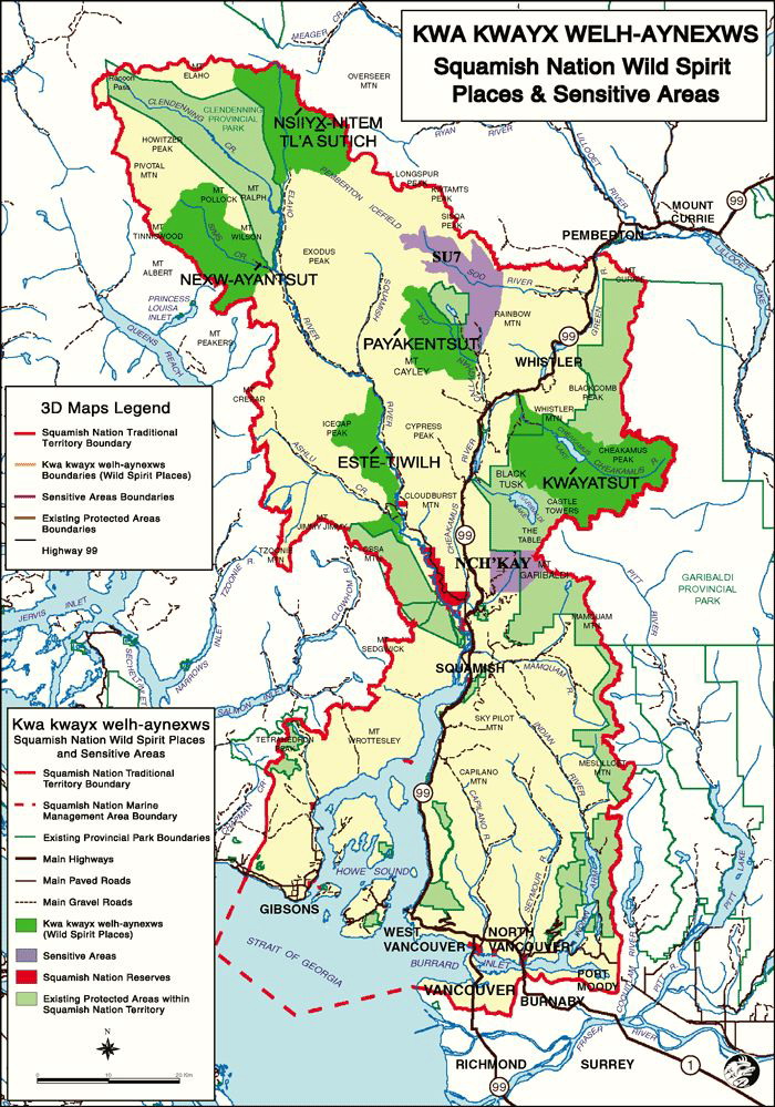
Xay Temíxw. (Click to enlarge) "It is important that the knowledge of the lands and resources of the traditional territory that reside within the family lineages of the Nation be brought forward and treated with respect, sensitivity and confidentiality. Access to this family information is earned over time through the building of trust. The Squamish Nation will uphold chiyax in collecting and sharing the collective knowledge of the Nation" Xay Temíxw. See a video of how the Squamish worked together to create this remarkable cultural and environmental initiative: Squamish Landuse Management Plan. See also the report A Gift To the World by the Western Canada Wilderness Committee. Some of the world's oldest groves of big trees are located in the Upper Elaho and Sims Valleys, the traditional territories of the Squamish and Lil'wat peoples. These rare treasures of biodiversity are part of the notorious cutblock called "Tree Farm License 38." In 1996, when Interfor (International Forest Products) began clearcut logging here, it sparked a protest movement. Squamish artist Aaron Nelson Moody carved "Cedar Woman" in 2000 to stand watch over the Elaho Valley (left). The Squamish gained control over the cutblock in 2005. See: BC Tree Farm License 38. |
||||
Squamish Chief Joe Mathias (1943 - 2000) warned his people: "We know that white bureaucrats, politicians and governments were not set up to look after our rights ... Our rights are not to be bartered away and extinguished" (1994, Our Chiefs and Elders). When the right to vote was restored to First Nations in Canada in 1949, the parents of Chief Mathias were the first aboriginals to vote in BC. In 1953 his father, Chief Mathias Joe Capilano, protested against an expansion of Lion's Gate Bridge on the Capilano Indian Reserve and was ridiculed: On Guard Against White Man. The right to control their territories and resources was brutally removed from First Nations. Musqueam Indian Band Chief Johnny (right) complained to the Royal Commission on Indian Affairs on 24 June 1913: "the food of the Indians is being seized and destroyed ... Before the whiteman came, the Indians used to have all kinds of game to live on, but since the arrival of the whiteman pretty nearly all the game has disappeared around here, even the fish in the waters are going the same way, and I say I did not destroy all those things which God made for us Indians - it is the whiteman who came to this country that almost destroyed our game and fish ... I want to be at liberty at all times to take and kill fish and game of all descriptions to support my family and for our own use. I don't want to be restricted by the whiteman's law" McKenna McBride Report. |

Chief Johnny (right) and Chief Jack Stogan, c. 1913. |
||||

"Indian Ranches on Burrard Inlet," c. 1868. When the first sawmill began operating on Burrard Inlet in 1863 it signaled the beginning of a new era of industrial exploitation, deforestation and degradation of First Nations lands and waters. As settlers occupied and took over the rich valley bottom land along the Fraser River they cut down the thousand year old trees, leaving a wasteland of massive stumps. A photo of two Chehalis First Nation members shows them standing beside the charred remains of an ancient cedar (right). Today tours are given to educate non natives about the cultural heritage of Chehalis Territory and to help protect its sacred sites and ecological health for future generations. See: Sasquatch Tours (Chehalis owned). |
When the Burrard Inlet was first photographed c. 1863, it was still a biologically pristine temperate rainforest with enormous ancient cedars and Douglas firs that provided shelter for First Nations people (left). Warriors were able to fend off potential settlers from Burrard Inlet until 1862 when the discovery of gold brought tens of thousands of Euro American miners on steam boats from San Francisco to the Fraser River. "Harrison River Indians," c. 1868. |
||||

"Indian canoe in Vancouver harbour," c. 1890. |
An early symbol of European conquest was the Catholic mission established in 1864 on the North Shore of Burrard Inlet at Slah-AHN, a Squamish village today known as Mission Indian Reserve No. 1. An archival photo c. 1890 (left) of a dugout canoe on Burrard Inlet shows the North Shore in the background, still largely intact. Smoke from a few of the sawmills can be seen along the shore. As Vancouver exploded in population size during the next two decades, the North Shore was ruthlessly deforested. Both the ancient cedar trees and the beautiful dugout canoes made from them vanished. For all First Nations on the Northwest Coast the cedar tree provided so many necessities that it was known as the tree of life. |
||||

"Kitsilano Indian Reserve," 1891. |
Indigenous land allocated as Indian reserves was mercilessly expropriated and reduced in size to facilitate urban expansion. See a graphic display of the shocking and illegal process by which the Squamish lost all of Kitsilano Indian Reserve No. 6, formerly the village of Snauq, from 1886 to 1980: Kitsilano Lands (Squamish Nation). A photo dated 15 August 1891 (left) was taken "near Jericho Charlie's home" on the Kitsilano Indian Reserve. The people are identified as: Mary (Yam - schloot); Jericho Charlie (Chin - nal- set); William Green; Peelass George; Jimmy Jimmy and Jack (Tow - hu - quam - kee). Chief August Jack Khahtsahlano (1867-1954), namesake of Kitsilano, was born at Snauq. He and his people were forcefully evicted by developers in 1913. Following their removal, the old growth forest of Kitsilano was logged, burned and the land subdivided. See: Conversations with Khatsalano. |
||||
The South Shore of Burrard Inlet, where downtown Vancouver today stands, had some of the largest trees in the world when the first sawmill began its operations here in 1865. Three decades later the trees were all gone and Vancouver had been laid out by surveyors. An 1898 photo shows the waterfron First Nations camp that once existed near the intersection of Alexander and Columbia Streets at a site now known as Crab Park or Portside Park (right). "Indians camped at Columbia and Alexander," 1898. |

"Indian camp at Columbia and Alexander Sts.," 1898. The camp seen in 1898 (above) is an ancient Squamish site called Luck Luck EE (Grove of Beautiful Trees) after the ancient maple tree grove that once grew here. By 1898 the site had been engulfed by development though the Squamish still camped here (left). In recent years, Crab Park has become a memorial to murdered and missing women, a disproportionately large number of them aboriginal. See the photo: Crab Rock. Greater Vancouver includes 22 Indian Reserves and ten First Nations: Katzie, Kwantlen, Kwikwetlem, Matsqui, Musqueam, Qayqayt, Semiahmoo, Squamish, Tsawwassen and Tsleil Waututh. For a reserve map, see: Indian Reserves in A Profile of Aboriginal People, First Nations and Indian Reserves in Greater Vancouver (2003). |
||||
|
Squamish Chief Joe Capilano (c. 1840 - 1910) is said to have borrowed the hereditary name "Capilano" from the Musequeam in 1906 when he led a delegation to England to meet the monarch and protest over the unresolved Indian land question in BC. When he returned, Capilano (right) organized a meeting of northern and southern tribes to gain solidarity for asserting self government. The white press derided his actions and labelled him a troublemaker. During his lifetime, Capilano witnessed the destruction of the Squamish land and waters. Homulchesan (whu - MU L- chits - tun) was the largest village on the North Shore, located at the mouth of the Capilano River. When he first led a group of surveyors to the source of the river in 1890, the watershed was still a pristine wilderness. But the ancient trees were soon demolished by loggers and a hydro dam was built in 1910 followed by extensive subdivisions. Today the village is known as Capilano Indian Reserve No. 5 and it is marked by Lion's Gate Bridge, a symbol of British colonial imperialism. Lion's Gate Bridge was part of a carefully engineered land grab and development scheme undertaken without proper Squamish consultation. In 1936 the Canadian Minister of Indian Affairs transferred land from the Capilano Indian Reserve to British Properties, a conglomerate owned by the wealthy Guiness family of Ireland. In 1939, during the first visit of reigning British royalty to Canada, the new Lion's Gate Bridge was glorified with a drive over by the King and Queen. No attention was given to the people on whose land it was built or to the ecological destruction it had caused. |

Chief Joe Capilano, c. 1906. |
||||

Moody Avenue and Seventh Street, c. 1911 |
The first sawmill on Burrard Inlet began operating in 1863 in what is now North Vancouver. Owned by the American lumber entrepreneur "Moody," it was soon exporting the valuable timber to Europe and beyond. A town grew up around the voracious sawmill: Moodyville Legend and Legacy. The big trees of Burrard Inlet were 100 meters in height, among the largest and most magnificent in the world. Once they were cut down, the land was slash burned, surveyed and subdivided (left). One of the first subdivisions in the new province was Woodhaven on Burrard Inlet, which offered large villa style lots in 1910. Premier Sir Richard McBride was a sponsor of this early real estate scheme. At the same time the government was conducting a punitive reduction of Indian reserve land. See: McKenna McBride Royal Commission. |
||||
|
Tsleil-Waututh Nation (Burrard Indian Band) people live on Burrard Inlet and share close cultural, family and historic ties with the Squamish Nation. Geswanouth Slahoot, or Tes - wah - no, best known as Chief Dan George (right), gave a speech on the confederation of Canada in 1967: "How long have I known you ... in the long hundred years since the white man came, I have seen my freedom disappear like the salmon going mysteriously out to sea. The white man's strange customs, which I could not understand, pressed down upon me until I could no longer breathe. When I fought to protect my land and my home, I was called a savage. When I neither understood nor welcomed his way of life, I was called lazy. When I tried to rule my people, I was stripped of my authority" Lament for Confederation. Se-quail-yah cooking salmon, c. 1940. |

Chief Dan George (1899-1981). Chief Dan George was born in 1899 on Burrard Inlet Indian Reserve No. 3 (above). He worked as a longshoresman for 27 years and served as chief from 1951 until he began a successful acting career in 1963. One of his most praised roles was in the classic film Little Big Man (1970) opposite Dustin Hoffman. Today his legacy continues with the Chief Dan George Centre which supports the self governance of First Nations communities. Chief Dan George lived on the Burrard Indian Reserve for his entire life. Se - quail - yah (left) was his wife. Here she is seen cooking salmon traditionally over an open fire on the reserve c. 1940. As Vancouver developed and the forests were cut down and paved over, the salmon and streams disappeared from Burrard Inlet, severely impacting the First Nations' way of life. |
||||

Diorama of a wolf in the Fraser River Canyon. |

Moon over Cheam. Chief Dan George belonged to the Wolf Clan and his lament to the wolf as a symbol of the vanishing wilderness and traditions of his people has become famous: "All of a sudden I realized why no wolves had heard my sacred song. There were none left! My heart filled with tears. I could no longer give my grandson faith in the past, our past." The wolf is a wilderness species that cannot survive the encroachment of its habitat by development and urban sprawl. As settlers and their industries took over the Fraser River Valley, the wolf was driven further into the mountains. A museum diorama (left) of the endangered BC wolf is on display in Los Angeles, an urban metropolis where the species was long ago exterminated. |
||||


Source: www.firstnations.eu Printed:
Copyright: All Rights Reserved. Researched, written, compiled, formatted, hyperlinked and encoded by Dr. Karen Wonders. Images and intellectual property rights reside with the credited owner. Commercial transmission and/or reproduction requires written permission. Use for educational and research purposes requires proper citation.